
Yesterday was our first day at the FGCU Vester Marine Lab on Estero Bay. It is quite a beautiful ecosystem, unlike any I have seen growing up in Northeast Florida. The picture above shows part of our waterfront lodging we have while experiencing this field intensive week here in Bonita Springs, FL. The first day started with a short lecture on paleotempestology and geology as a whole. Then we took an exciting trip out to the inner bay margin and back barrier bay to take core samples of the sediment. Below you can see us learning how to actually take a core sample. At each site we had a aluminum pipe of a few meters long that we had to push into the ground with the help of adjustable handles. Let me tell you that was not an easy task- it took teams of students to pull them out of the ground without messing up the sediments- but we did get some really cool samples.

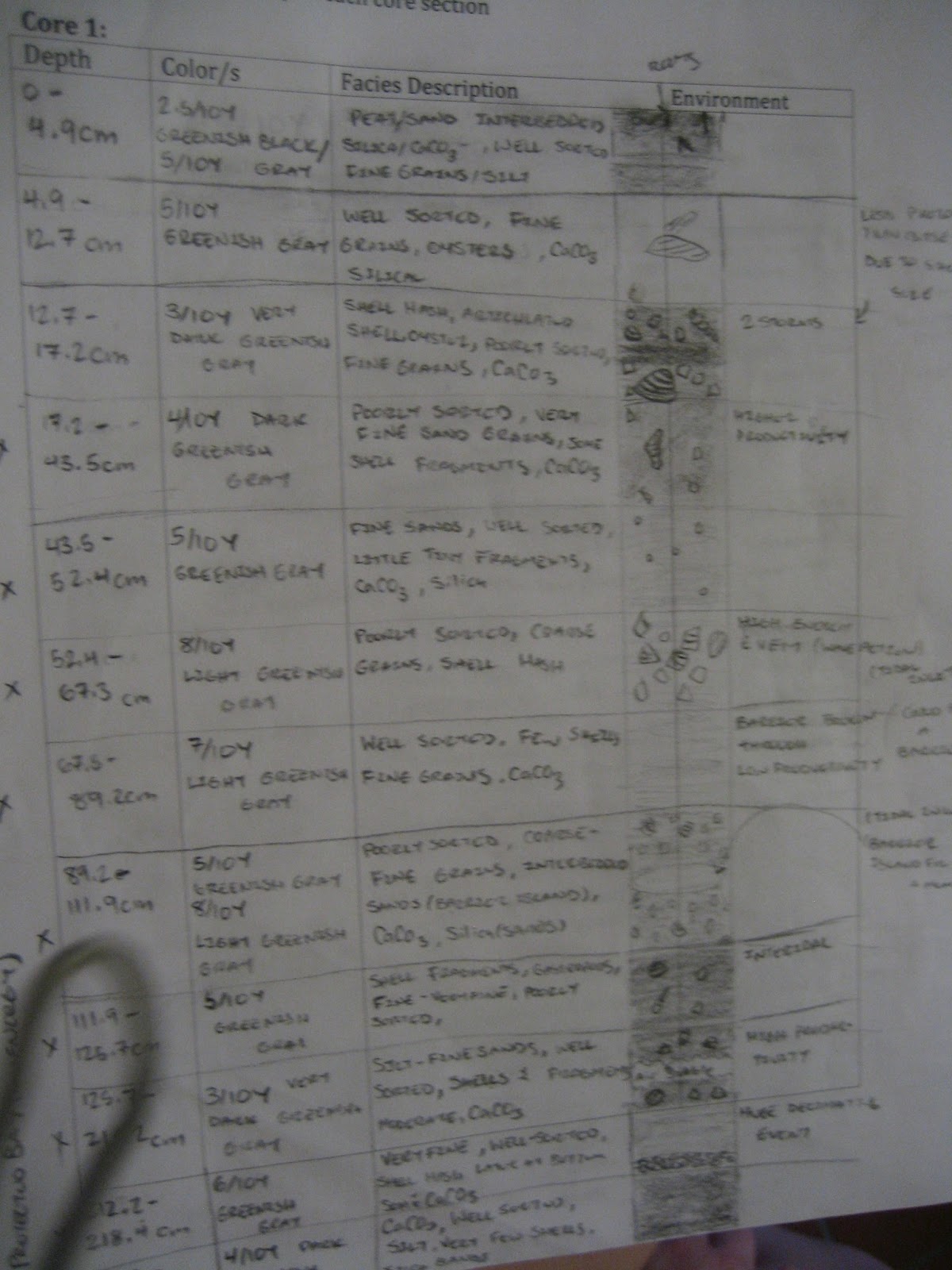
After we returned to the lab we took a short break for lunch, after which our lovely geology professor Dr. Jo Muller cut our core samples in half so we could analyze the sedimentology of each. In the picture below you can see (from top to bottom) the top half of core 3, the bottom half of core 3, the top half of core 1 and the bottom half of core 1. Some of the sediments in the bottom of the cores goes back over a thousand years. It was also quite amazing to see the differences in the environment over time, especially the obvious storm events. For example in the very bottom core to the far right there is a patch of sediment that is much lighter than the sediment on either side, and if you look really close a very thin layer of shell hash on the right side of that layer. This conceivably represents a major storm event where there was a lot of sediment over-wash into the bay because of the high amounts of silica-based grains, which are found to be from mainland sources. The shell layer is very thin because the area of the bay that this sample was taken from was very protected with things like dense mangrove populations so larger fragments were not able to drift that far into the bay.

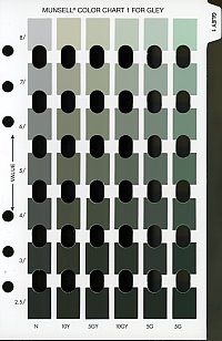
After the core samples were split open, we were able to bring the samples inside the la and analyze them a little bit closer. We took note of every little detail from each layer and recorded it in our stratigraphic log. We had to determine the grain size, the composition of the grains as well or poorly sorted, the color of the soil based on the Munsell Soil Chart (The picture provided in the previous link is actually the chart I used the most to identify the color of the layers in our core sample, but there are several other charts.), whether or not shells or mangrove roots were present, if the soil was composed of calcium carbonate or silica and anything else we could determine. It was a lot of work, but it proved to be very interesting, especially when trying to determine the history of that part of the bay.

Day 2 at the Vester Marine Lab turned out to be a very very long and exhausting day. We began our morning with a lecture on the forces driving the motion in the estuary as well as the types of estuaries that exist as based on the residual circulation of the water. After that crash course in physical oceanography, we broke into two groups: one that measured the salinity, dissolved oxygen, temperature and density on the surface and bottom at 7 different stations from the mouth of the Imperial River to the head, and another group who set off in canoe's to measure the water current in 3 locations over time. I was lucky enough to be be in the canoe station that was furthest away from Vester. To make the trip even more memorable, my partner and I actually went over a kilometer out of the way because we made a wrong turn in the confusion that is Estero Bay. By the time we got to our location within the Imperial River, we were hot and exhausted but we still had 2 hours of measurements to take using our handy waterproof GPS and depth finder and a grapefruit.


We had to follow the grapefruit for 10 minutes and log the starting and ending longitude and latitude, then we had to go back as close as we could to the starting location and repeat the process numerous times. After the first two go-arounds, Jessica and I found it was easier and much less hot to just swim after our grapefruit we fondly named Joey. A few time boats would go by, and seeing the grapefruit floating in the water, stop, point and stare. There were a few times Jessica and I thought they were going to take it out of the channel and disrupt our measurements so we had to explain to them we were doing research. Our trip back to Vester was an adventure in itself- we had to go against the flood tide and were forced to weave back and forth in the mouth of the river and we almost lost my back pack by an over looking branch- twice! but somehow we still managed to make it back before the crew on the actual boat. I'd say its a job well done!
That must have been funny.."DON'T TOUCH THE GRAPEFRUIT!". Did you eat your research subject after the study?
ReplyDeleteI love the pictures that you took! Where can I find them?!?! :]
ReplyDelete